Road Repurposing
As part of the Land Transport Masterplan 2040 (LTMP2040), LTA is working towards a more inclusive land transport system as well as safer and more pleasant journeys for all.
LTA is studying how Singapore’s road infrastructure can better support walking and cycling in neighbourhood centres to create a more liveable and inclusive environment for all. As part of this, we are exploring possible locations where part of the road can be pedestrianised or converted to create wider footpaths or cycling paths. A pedestrianised street is similar to a very wide footpath, whereby the road is closed off to vehicles and reserved for pedestrians, bicycles, non-motorised Personal Mobility Devices (PMDs), and Personal Mobility Aids (PMA). In some instances, where it is safe and feasible to do so, the repurposed roads may also be used for community activities. Features may also be added to prioritise public transport or to improve its accessibility and connectivity.
We believe that feedback from the community is important in creating a safer and more inclusive transport environment for all. LTA welcomes you to provide your feedback through our regular feedback channel. More projects will be announced progressively.
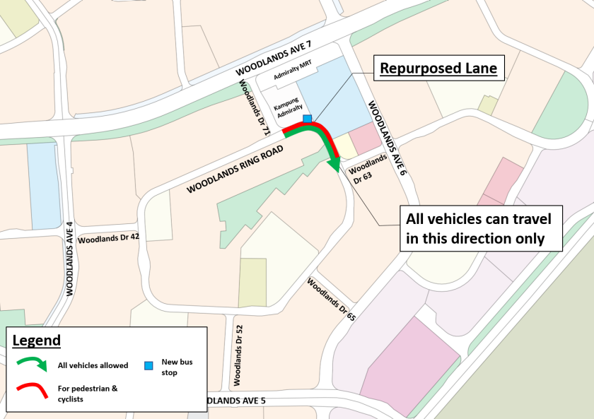
Woodlands Ring Road (Kampung Admiralty)
_resized")
_resized")
Works to partially pedestrianise Woodlands Ring Road have been completed, with covered linkways, wider footpaths and a new bus stop
Creating safer and more pleasant streets to key amenities and transport nodes
The pedestrianisation of Woodlands Ring Road (between Woodlands Drive 71 and Drive 63) is intended to provide a safer and more seamless walking connection for residents to Kampung Admiralty and Admiralty station. With the widened footpaths and the new covered linkways, pedestrians and cyclists of all ages can walk and cycle more conveniently, safely and comfortably as they make their way to their neighbourhood centre.
Location Map
Phase 1– Pedestrianisation of Woodlands Ring Road (Westbound) with bus-only road (Eastbound) (Completed)
In February 2021, the lane along Woodlands Ring Road (between Woodlands Drive 71 and Woodlands Drive 63) opposite Kampung Admiralty was closed off from vehicles using barriers. This created a pedestrianised street which enhanced pedestrian safety and offered seamless connectivity for residents of all ages to and from Kampung Admiralty, Admiralty station and the surrounding residential blocks.
The lane nearer to Kampung Admiralty was converted into a bus-only road. Bus services 901M and 912/912A remained unaffected, and commuters who used these bus services benefited from a smoother and faster journey via the bus-only road. Phase 1 was completed in August 2021.
Phase 2 –Transition to Permanent Infrastructure (Completed)
LTA took in feedback from the local community throughout Phase 1, through online surveys, door-to-door engagement sessions and a focus group discussion. The feedback and insights from the local community were taken into account when shaping the permanent infrastructure.
The lane along Woodlands Ring Road (between Woodlands Drive 71 and Woodlands Drive 63) nearer to Kampung Admiralty has been permanently pedestrianised, while the lane opposite Kampung Admiralty has been open to both buses and private vehicles to travel in the eastbound direction along Woodlands Ring Road from Woodlands Drive 71 to Woodlands Drive 63. Works were completed in March 2023.
The completion of covered linkways, a new bus stop and widened footpaths along Woodlands Ring Road has brought greater convenience to the residents. The new bus stop provides the residents with direct accessibility to existing bus services 901M and 912/A, enhancing their connectivity to en-route amenities and schools. Cycling path works will be completed in tandem with the wider Woodlands town cycling network to provide greater active mobility connectivity for residents. Works for the wider cycling network are targeted to complete progressively from 2024.
Havelock Road

Widened footpath at Havelock Road
Creating a safer and more pleasant pedestrian experience
The widening of the footpath in front of the row of shophouses along Havelock Road (between 715 Havelock Road and 745 Havelock Road) is intended to provide a safer and more comfortable walking experience for all residents and visitors to the area. With the widened footpath, pedestrians and cyclists can more conveniently and safely make their way around the Beo Crescent neighbourhood centre.
Phase 1 – Removal of roadside parking lots along Havelock Road (Completed)
Under Phase 1, roadside parking was removed, and barriers were used to create a wider footpath. The widened footpath provided a more comfortable walking experience for residents and visitors, as they walk past, browse, or wait in front of the shophouses. It also improved connectivity through the various residential and commercial sections along Havelock Road.
Ample parking is available in the opposite and adjacent multi-story public car parks, located at Blocks 44A, 28A and 51, which are sheltered and convenient to use. The lower traffic environment resulted in a safer and more pleasant experience for everyone. Phase 1 took place from March to September 2021.

Location Map
Phase 2 – Permanent Infrastructure (Completed)
We received feedback from the local community during Phase 1, through online surveys and engagement sessions with stakeholders. The proposal was welcomed by the local community, and their feedback and insights have been taken into consideration, including the provision of barrier-free access.
LTA has completed the works to permanently widen the footpath in December 2021. With the widened walkway, residents are able to walk more comfortably to the shophouses and amenities nearby.
Civic District


Artist’s impressions of the reimagined Civic District at Connaught Drive (For illustrative purpose only)
Images Credit: NParks
Creating a Pedestrian-Friendly Civic District
To create a green and pleasant walkable environment, LTA, together with National Parks Board (NParks) and Urban Redevelopment Authority (URA) has further enhanced the walkability of the Civic District by pedestrianising Connaught Drive and Anderson Bridge/Fullerton Road.
Since December 2021, Connaught Drive and Anderson Bridge/Fullerton Road have been closed to all vehicular traffic. To maintain accessibility within the Civic District, Parliament Place was reopened to all vehicular traffic. The pedestrianised area has created opportunities for agencies to work with stakeholders in the Civic District to bring new arts and cultural activities outdoors, livening up the area. Visitors have been able to enjoy a seamless walking experience amidst lush greenery between the Esplanade Park, Empress Place and Padang.

Location Map


Pedestrians and cyclists enjoying the closure of Fullerton Road/Anderson Bridge during the day (left) and night (right)

Road closure of Fullerton Road and the relocated coach pick-up/drop-off points
Tiong Bahru (Seng Poh Road and Eng Hoon Street)


Pedestrianisation works at Eng Hoon Street are completed (left)
Kerbless crossing at Seng Poh Road (right)
Creating a safer walking environment and more community spaces at Tiong Bahru
The pedestrianisation of Eng Hoon Street and widening of footpaths at Seng Poh Road and Lim Liak Street have created a safer walking environment and free up spaces for community use. With this project, pedestrians, especially senior residents and children, have been able to walk more safely and comfortably to access the Tiong Bahru Market and other shops and eateries within the Tiong Bahru area.
Phase 1 – Pedestrianisation of Eng Hoon Street and removal of roadside hourly parking lots along Seng Poh Road and Lim Liak Street (Completed)
To create space for community use, temporary kerbs and planter boxes were used to close off a section of Eng Hoon Street in Phase 1. The roadside hourly parking lots along Seng Poh Road and Lim Liak Street were also removed to create wider footpaths and the existing taxi stand at Seng Poh Road relocated to Lim Liak Street. Phase 1 took place from March to September 2022.
Phase 2 – Transition to Permanent Infrastructure (Completed)
In August 2023, we completed the pedestrianisation of Eng Hoon Street and the widening of the footpath along Seng Poh Road and Lim Liak Street. LTA had previously taken in feedback from stakeholders and residents through an online survey and the Lively Places Challenge Workshop. To enhance accessibility to and from the Tiong Bahru market, we have built more loading and unloading bays around the market, and a new pick-up and drop-off point with a shelter at the entrance to the market. Works for the relocated taxi stand with a shelter and a high covered linkway across Lim Liak Street is ongoing and slated for completion in 2024.
The widened footpath and pedestrianised Eng Hoon Street are well utilised and the new drop off points have provided more convenience to visitors to Tiong Bahru Market. The additional loading and unloading bays are also welcomed by the hawkers.
There are alternative parking lots in the vicinity at 61 Seng Poh Lane and 78 Moh Guan Terrace, which are a 3 to 5 minutes’ walk away (see location map below). The lower traffic environment has given everyone a safer and more pleasant walking experience.

Artist’s impression of the wider footpath and relocated taxi stand at Lim Liak Street (For illustrative purpose only)
Choa Chu Kang Terrace

Artist’s impression of the pedestrianised Choa Chu Kang Terrace (For illustrative purpose only)
LTA will pedestrianise an 80-metre-long stretch of the road (from Choa Chu Kang Avenue 1 to the loading/unloading access point of Sunshine Place) to give residents a safer and more comfortable walking experience.
Sunshine Place serves as the neighbourhood centre for residents living in the vicinity. With the opening of the food court at Sunshine Place, together with the future opening of the Jurong Region Line (JRL) station along Choa Chu Kang Avenue 3, we anticipate that it will bring even more visitors to the area.
The proposed conversion of a section of Choa Chu Kang Terrace to a pedestrianised street will allow for a more comfortable walking experience for residents to and from Sunshine Place. Safety would also be further enhanced with the removal of the need for pedestrians to interact with traffic. There will be signs to direct vehicles to enter Sunshine Place carpark and its loading/unloading points via Choa Chu Kang Avenue 3.
Works have started in December 2023, with a tentative completion date of 4Q2024.

Location map of planned pedestrianisation at Choa Chu Kang Terrace
Yung Sheng Road

Artist’s impression of Yung Sheng Road (For illustrative purpose only)
LTA will pedestrianise an 18-metre-long stretch between Taman Jurong Shopping Centre and Taman Jurong Market and Food Centre.
The shopping centre and market/food centre serve as key amenity centres for the entire Taman Jurong Community, and we have observed a high volume of pedestrians crossing between the two developments.
The proposed conversion of a section of Yung Sheng Road to a pedestrianised area with a covered linkway and improved barrier-free access, will allow for a safer and more comfortable walking experience.
Existing entrances to both Taman Jurong Shopping Centre and Taman Jurong Market & Food Centre car parks, loading/unloading bays and pick-up/drop-off points remain open. As Yung Sheng Road will no longer be passable between the main Yung Sheng Road and Yung An Road, motorists will be directed to travel along the main Yung Sheng Road and Yung An Road.
Works have started in December 2023, with a tentative completion date of 4Q2024.

Location map of planned pedestrianisation at Yung Sheng Road